Assessment of influencing factors on non-point source pollution critical source areas in an agricultural watershed
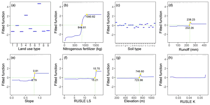
 Fig. 6. Partial dependence plots of the incidence of TN-CSAs on influencing factors
Abstract
Critical Source Areas (CSAs) are areas that contribute disproportionate high levels of non-point source (NPS) pollution to receiving waters, and their occurrence is the result of the complex interaction between the factors related to the sources and transport processes of NPS pollution. A systematic understanding of how these influencing factors affect CSAs is essential for successful watershed management. In this study, we applied a statistical data mining technique boosted regression tree model to quantify the contribution of eight influencing factors (soil type, slope, elevation, RUSLE LS factor, RUSLE K factor, runoff, fertilizer application rate and land use) on two types of CSAs (TN-CSAs and TP-CSAs), as well as the marginal effects and potential thresholds of influencing factors on the occurrence of CSAs. Results show that land use (37.35%, 25.03%), fertilizer application (36.93%, 57.83%) and soil type (17.59%, 13.70%) have higher importance in determining the occurrence of TN-CSAs and TP-CSAs; and the incidence of CSAs is positively correlated with most factors before the threshold for each influencing factor, after which the marginal effect largely leveled off or dropped slightly; TP-CSAs have essentially the same characteristics as TN-CSAs, but TP-CSAs are more likely to occur in areas with an annual runoff of around 244.92 mm. In addition, this study discussed the application of machine learning techniques in predicting CSAs under climate change without physical-based models, as well as a preliminary watershed management planning for NPS pollution control in the study watershed. These results provided important information for nutrient management regulations.